

Welcome to Terra-i


Welcome to our new website! In this portal to the Terra-i habitat change monitoring system, you will find a short description of our input and output data, you'll also be able to download the latest detections or view them with our web mapping tool. Don't miss our videos section where deforestation hot spots are presented, you'll also be able to request that we generate new video in areas of your interest. You can visualise habitat change directly but to access the data in GIS formats , you will need an account to our portal, if you don't have one, you can sign in by filling the registration form.
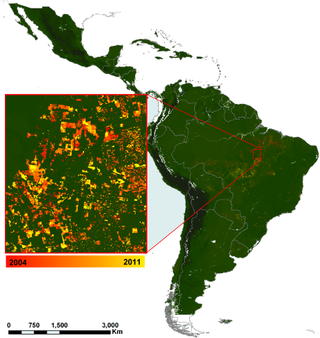
Terra-i: An eye on habitat change
Habitat conversion is contributing to widespread loss of biodiversity and other critical ecosystem services, yet in many parts of the world the scale and pattern of habitat loss goes unmonitored. Decision makers at multiple scales (local to national to regional) need timely information on land-cover change, requiring the information to be as accurate and recent as possible in order to prioritise interventions and act upon new land-cover change trends in a timely manner. The high temporal resolution (16 days) of MODIS NDVI data (product MOD13Q1) lends itself to being used to monitor land cover across large extents, but a combination of massive volumes of data and large amounts of noise in the time-series make this endeavour a challenge. We developed a methodology for detecting anthropogenic land-cover change across the tropics, which is capable of providing near real-time monitoring of habitat loss.
The methodology is based on the premise that natural vegetation follows a predictable pattern of changes in greenness from one date to the next that are brought about by site-specific characteristics and climatic conditions over the preceding days. We use a Bayesian-probability based neural network to learn how the greenness of a given pixel responds to a unit of rainfall (derived from the TRMM daily rainfall product 3b42), then we apply the model to identify anomalies in the time series - which can then be attributed to human activities (i.e. non-natural fluctuations in greenness). The methodology aims to demonstrate a potentially powerful means of monitoring habitat loss at a temporal and spatial resolution that is relevant for decision makers.


The Terra-i team together with CRS El Salvador under the Raices project carried out a virtual workshop through the teams platform to technicians from the Ministry of Environment and Natural Resources, CARITAS, Universidad El Salvador, CENTA, about the Mapping of land cover using remote sensors and open source tools such as GEE, SEPAL and QGIS- Plugin Semi Automatic Classification.


Near real-time vegetation loss detection in Southwestern Ethiopia: calibration, validation, and implementation of the Terra-i system


The Alliance of Bioversity International and the International Center for Tropical Agriculture (CIAT) (the Alliance) conducted a training for local stakeholders on the use of Terra-i as part of the collaboration with the Netherlands Development Organisation – SNV in the Coffee Agroforestry and Forest Enhancement for REDD+ (CAFÉ-REDD) Project.


From May 8-12, 2017, the Terra-i team, together with staff from the DGOTA of Peru's Ministry of Environment, carried out the first field validation of vegetative land cover changes detected during Terra-i monitoring for 2016 and 2017, using the technology UAV. This work was carried out under the framework of the project “Sustainable Amazonian Landscapes”. The team carried out over-flights with a Phantom 3 advanced rotor drone and a fixed-wing Ebee drone in seven townships of Yurimaguas. The objective of this work was to recognize the dynamics of land cover and land use changes in the region while at the same time to validate the accuracy of the detections of forest loss being monitored by Terra-i in Yurimaguas.


The Terra-i team has worked hard on renovating Terra-i’s website since early this year. A set of new features on the website provides interactive contents and facilitates adaptation to the mobile devices of our users. The fresh website was developed using the latest update of an open-source, Java-based web system, Magnolia CMS 5.4.4. This update was customized to add different categories of interaction such as news, vegetation cover changes, and information, among others.


Globally more than 1 billion people depend on forests for their livelihoods. Forests play a crucial role in climate regulation, ecosystem services provision and regulation, water supply, carbon storage and many other functions that support biodiversity. Currently the global rate of deforestation is substantial, and there is a growing need for timely, spatially explicit data that flag natural vegetation changes due to human activities.


The latest update of Terra-i has been used with the Co$ting Nature ecosystem services assessment tool to understand the impacts of recent forest loss in Colombia on biodiversity and ecosystem services.


During the 1st and 12th of June 2015, the Terra-i team, together with the Instituto de Investigaciones de la Amazonía Peruana (IIAP) and the Universidad Nacional Agraria La Molina (VLIR-UNALM), conducted the second field validation of the data produced by the Terra-I system. This time, the study area was the Yurimaguas district, Alto Amazonas province, Loreto region (Peru). We used information on populated places, main roads, rivers and information on land cover changes detected for 2013, 2014 and 2015 to define the 65 sampling points (or Terra-I pixels) for the validation process (Figure 1).