
Road Impact Assessment in Latin America: Results of Five Case Studies


Terra-i participated to a collaborative consultancy project conducted by the International Center for Tropical Agriculture (CIAT), the Nature Conservancy (TNC), and the Conservation Biology Institute (CBI) for the Environmental and Social Safeguards Unit of the Inter-American Development Bank. The main goal of this study is to provide tools that will allow analyzing of the impact of large-scale road projects on natural habitats. The study analyzes the impact of five road infrastructure projects (Fig. 1) in Latin America: 1) the Santa Cruz-Puerto Suarez Corridor in Bolivia, 2) the BR-364 Highway in Brazil, 3) the Pan-American section in Darien-Panama, 4) the Trans-Chaco Road in Paraguay, and 5) the IIRSA Integration Corridor in Peru.

Figure 1. Localization of the 5 infrastructure projects
The development of road projects in high-value ecosystems, and nearby protected natural areas, increases pressure on natural habitats, threatens biodiversity conservation, and encourages the conversion of forest land to agricultural and/or livestock systems. Roads provide access to previously remote areas. This opens the way to drivers of deforestation and land-use change, as demonstrated by all 5 road infrastructures projects presented in this study. The patterns of deforestations following road projects over time are extremely diverse, which points to a great variety of drivers and variation in their influence in different countries and their economies, as well as natural factors and policies which channel, impede or influence the dynamics of the land use and land cover change.
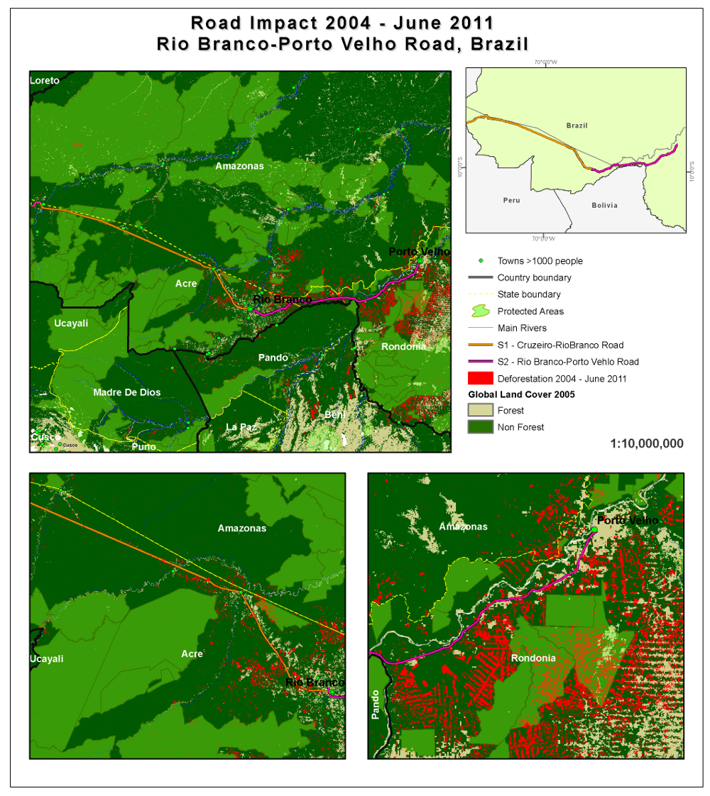
Figure 2. Road Impact 2004 - June 2011, Rio Branco - Porto Velho - BR-364 Highway
Local, national and international policies are essential and should be in place before, during, and after road construction, as they can significantly reduce the number of hectares deforested during and after project completion.
It is anticipated that infrastructure allows for the expansion of economic activities. In this sense, national and regional policies and incentives to promote sustainable and environmentally friendly agricultural practices are also important.
To read more about the results of this project you can access the full publication here (link http://www.iadb.org/en/publications/publication-detail,7101.html?id=70018) or read the detail reports made available in Terra-i publication section (link http://www.terra-i.org/terra-i/publications.html)
Acknowledgements: This Consultancy Project was conducted by the International Center for Tropical Agriculture (CIAT), the Nature Conservancy (TNC), and the Conservation Biology Institute (CBI) for the Environmental and Social Safeguards Unit of the Inter-American Development Bank. This project was supported with funds from the German Federal Bundesministerium fuer wirtschaftliche Zusammenarbeit und Entwicklung (BMZ) in the framework of a cooperation program between the Inter-American Development Bank (IDB) and the Deutsche Gesellschaft fuer Internationale Zusammenarbeit (GIZ).


IDENTIFICACIÓN DE CAUSAS DE PÉRDIDA DE COBERTURA VEGETAL EN LAS ÁREAS DE INTERVENCIÓN DE LA ACTIVIDAD GOBERNANZA EN ECOSISTEMAS, MEDIOS DE VIDA Y AGUA (USAID/GEMA) EN EL OCCIDENTE DE HONDURAS


MAPEO DE COBERTURAS DE LA TIERRA PARA EL 2017, EN EL OCCIDENTE HONDUREÑO SOBRE ÁREAS DE INTERVENCIÓN DE LA ACTIVIDAD GOBERNANZA EN ECOSISTEMAS, MEDIOS DE VIDA Y AGUA (USAID/GEMA)


CUANTIFICACIÓN DE LA DEFORESTACIÓN EN LAS ÁREAS DE INTERVENCIÓN DE LA ACTIVIDAD GOBERNANZA EN ECOSISTEMAS, MEDIOS DE VIDA Y AGUA (USAID/GEMA) EN EL OCCIDENTE DE HONDURAS


An international team of scientists*, involving entomologists, conservation biologists, agro-ecologists and geographers, has just revealed how on-farm insect biological control can slow the pace of tropical deforestation and avert biodiversity loss on a macro-scale. The case study concerns biological control of the invasive mealybug Phenacoccus manihoti with the introduced host-specific parasitic wasp Anagyrus lopezi in Southeast Asia. The results of this study have just been published in Communications Biology – Nature.


CIAT and the Terra-i team are pleased to announce the publication of a new study in Paraquaria Natural, the most prestigious journal in Paraguay dedicated to biodiversity and the conservation of nature.


New deforestation hotspots point the finger at my favourite fruit I love Terra-i, but today I hate it. A lot. The system uses satellite images to track deforestation in the Amazon in near-realtime. It’s extremely accurate: if a bunch of trees come down somewhere – no matter how remote – Terra-i picks it up. Cool, right? Not today. CIAT’s Louis Reymondin, the system’s chief architect, dropped the bombshell over coffee: it looks as though hundreds of hectares of rainforest in Peru are being trashed by… papaya.


The production of geospatial data related to land-use and land cover changes by governments and civil society organizations has vastly increased during the last decade. Going beyond the valuable information (location, rates and absolute values of changes) provided by these datasets, it is important to have a better understanding of the spatial configurations and composition of the detected change areas at multiple spatial resolutions and time periods. Alejandro Coca-Castro’s research is aiming to map types of spatial deforestation patterns in the Amazon rainforest through the integration of landscape fragmentation metrics and data mining techniques. The research will contribute to the understanding of two deforestation datasets (Terra-i and GFC) and is part of his master dissertation at King’s College London. This blog post highlights Alejandro’s research methodology, preliminary findings and challenges.


Ecuador is recognized as one of the biodiverse hotspots on earth, underneath the Amazon rainforest lies the country’s oil reservoir. With the oil companies and cleared routes come settlers, therefore more and more of this diverse rainforest is being cut down. Since the oil concerns entered the Ecuadorian Amazon 45 years ago, they keep exploring and exploiting the area. The Terra-i detections reveal a total habitat loss of 87,525 Ha, 16,943 Ha (19%) is part of protected areas, between January 2004 and February 2015.